http://the-blogged-drain.blogspot.com/?zx=413c8bf687be04b9
Adrian Cashman
CERMES
University of the West Indies
PO Box 64
Bridgetown
St Michael
Barbados
Tel: (246) 417 4829
Fax: (246) 424 4204
http://the-blogged-drain.blogspot.com/?zx=413c8bf687be04b9
Adrian Cashman
CERMES
University of the West Indies
PO Box 64
Bridgetown
St Michael
Barbados
Tel: (246) 417 4829
Fax: (246) 424 4204
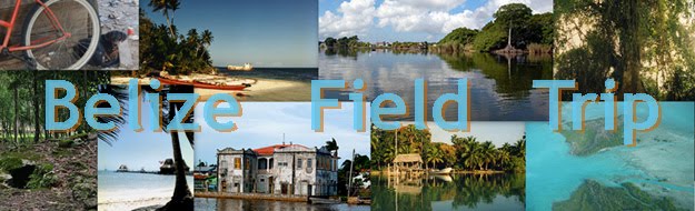
Attached is a link to the photo album for the recent field trip to Belize. I've also tried to locate each of the photo locations with Google maps.
Excellent tour as usual, Mr. Lanza was once again an informative and entertaining guide. The tour of the laboratories, the water treatment and the wastewater facilities, with the explanations that are an integral part of the tour give one of the most informative insights into these aspects of water management. What is for me particularly interesting is that this is undertaken by a commercial undertaking and we are told the reasons why it is so important for their business. I think that we come away with a much better understanding than from other facilities. The fact that Mr. Lanza has years of experience of working in the industry as well as his previous background with the water authority means that he is able to bring all that background and put it at our disposal.
Among the aspects that we did not cover were the potential impact that climate change might have on the undertaking – it would have been instructive to have heard what Mr. Lanza had to say. The other aspect, of a more technical nature would have been to consider the efficiency of water use within the two production facilities and how you would go about doing a water audit in order to determine this and then compare this against a benchmark set of figures. This would also then feed into how you would go about estimating the water demand and consumption of the facilities for given levels of production.
Two main things struck me this year as being different about this day’s visit. Firstly, the areas of pine forest that had previously been affected by pine bark beetle were showing a lot more ground cover than previously and the vegetation cover in general was much more prolific. Secondly, the water level in the dam was the lowest that we have seen it, no surprise here really given what we have been told of the rainy season so far.
This year we got to go inside the dam itself and walk a little way along the gallery. It’s much bigger than the other dam galleries I’ve been though. There is some instrumentation to measure seepage through the dam. An interesting snippet that I didn’t know previously was that the dam construction technique used was roller compaction of the concrete.
During the discussion with Mr Reynolds the Chief Engineer the matter of water quality came up. There were a couple of points that I noted. First he said that one of the reasons for the high level of sediment that they had on one occasion was that during a period of high inflow the water was ‘short cutting’ across a bend in the river and as a result it picked up a lot more sediments as well as other woody & vegetation debris. As this was carried in on colder water it was near the bottom of the impoundment and when released through the dam valves it carried the sediment with it. Dam impoundments will of course change the water quality of the water stored from that of the natural flow which under certain conditions impact the downstream ecology as much as the alteration in flow regimes.
Spent quite a bit of time going through the assignments, after we had reached the Climate Change Centre’s offices. There were some clarifications that needed to be made to them. For example, the results of the fieldwork at Monkey River need to be shared among all the groups so that all can write them up and have a good overview of what was done. So the information needs to be shared. Also there was no fieldwork as such on the Macal River at the dams so you cannot include what’s not done. And the Assignment 3 should be about 2000 words.
Whilst at the Center we met with the Deputy Director of Petroleum and Mining and had a very interesting conversation about sand and gravel abstraction in Belize. He has offered to get to us information on previous sand and gravel abstractions from the Bladen and Swasey Rivers. Much of the abstraction in the upper part of the Swasey is done for the Ministry of Works and that therefore there is somewhat less control over what is taken out. It would appear from what he was saying that under his leadership the abstraction regime has tightened up considerably, even though they have a small number of people. They rely on ‘whistle blowing’ as well as unscheduled inspections three times a year. He also said that he would like to collaborate on future field trips in a similar way to what the Hydrology section does at present.
I am somewhat concerned over the deterioration of the water quality samples, we will have to get them to the Laboratory in the morning. Even then I am not sure if we will get any reliable results. This is an aspect we are going to have to look at in the future as we really must get them tested as soon as possible. I read that the University of Belize was (in 2007) setting up a water quality laboratory – we should look into that and see if there is some way in which we could share resources.
Aquifers and their water quality, water quality of surface water, water issues within communities and if there is any competition between users in the area. It was mentioned that there were transboundary problems in the upper part of the watershed. Flooding was mentioned as a problem and that the farmers were developing tir own dams to capture run-off which was partly in response to changes in the legislation governing water allocation. The remark was made that the legislation changes would only affect domestic water – to be checked.
Checks including impact on water quality, on the first use of pesticides is done through the Pesticides Control Board. Other than that there is n control of water quantity or quality. The Mennonites said that they reuse a lot of the water that they take out of the Rio Bravo, it is stored in the drainage channels. Salinity levels are vey high.
We were told about a ‘cooperative’ community that does rain-fed rice growing in the upland areas above Blue Creek, these we found including the mill where they bring the grain.
Travelling down to Hill Bank we noticed just before the entrance a centre point irrigation system and it later transpired that the land development was being undertaken by the Mennonite community. One of the reasons we were later told for the buying up of the land by Programme for Belize was to prevent land conversion by the Mennonites to agriculture. They were growing beans and sorghum in the area.
Not that much of interest in what we did here to water resources. The possibilities are to look at surrounding land use practices and their impact on water resources – development pressures, land conversions especially the difference between that undertaken by Mennonite communities and Metitzo communities in the Orange Walk District. It might also be interesting to think about what impact land conversion to agriculture is having on the recharge and run-off to creeks in the area. In theory if there has been substantial conversion then there should be impacts but quite what they might be would have to be determined.
Some basic subsurface geology and hydrogeology mapping would be required.
The change over to the pine forest areas is quite abrupt. What was also surprising was the dampness of the soil underneath the floor litter even though it had been quite some time since there had been rain.
Excellent tour as usual, Mr Lorensa was once again an informative and entertaining guide. More to follow.

We got the students together this evening to discuss the video project. The students are in three groups and each group must create a 5-minute video on a topic of their choosing but should be related to an activity that they have seen or worked on during this field trip. Water resources or climate change or both should figure prominently in the project. Each group has been given an HD Flip video camera.
As a start, we told them to treat this project as one would a paper but without all the words. Here are some more guidelines:
1) Formulate an idea, a direction, or theme that you want to go with the video.
2) Just as you would for a research paper, draft an outline. What pieces do you need for your video? Do you need interviews? Do you need imagery of certain sites? Do you need particular sounds recorded? Do you need to do more research?
3) On the trip capture video and images with your project in mind. Talk to the other groups to see if they might have material you can use for your video project.
4) Piece your video together to see what you’re missing. Add still images. If you don’t have a shot of what you wish to highlight, search for an image in Flickr Creative Commons or some other open access, share-alike source.
5) Make a script then do a voice over. Practice it a few times to get the timing down.
6) Add a title clip and also add a clip with your names, dates and places.
Then I walked them through the use of Windows Movie Maker. Though they are using Flip video cameras and could use the Flip software, Movie Maker is a better solution for creating videos. It’s free with the Windows operation system and quite easy to use. And none of the students (or professors) are using Macs which would mean they would use iMovie software.
To get started, open Movie Maker and save your project with a new name. Save often!
Import video by navigating to your video clips. Then load those clips from your Collections to your movie project. Drag your clips into the Video timeline. You can also copy the clips from the Videos folder from you’re My Documents folder directly into Movie Maker’s timeline. You can make your clip shorter and reduce the unwanted parts of a clip by using the slider at the end or beginning of a clip (this will be a red double arrow).
Importing pictures is a way to utilize images of topics that you did not get good video footage of. The default length of time for an imported image is about 5 seconds; you can modify that to be whatever length you wish. Keep in mind that pictures will not have any sound so you will need to have some sort of audio over those images.
With both video clips and pictures, you can fade from one into another by slightly overlapping two clips or photos. This makes a smooth transition.
Remember to save.
There is a narration tool built into Movie Maker. A small microphone shows up in your tool bar. Click that and you’re ready to record. Once your recording is done, stop, save and your recording is found in your audio line of your project. You can also bring in other sounds that you’ve captured by importing or dragging clips into the audio timeline.
Create a descriptive title using the title wizard. Create a second title with the names of your group, date(s), and location. You can add text over your video clip or photograph clip by adding text over the selected clip. For text, you should use a sans serf font like Arial or Trebuchet and not a serif font like Times Roman or Georgia.
Save again!
Once you feel your five-minute video is as exactly how you want it, go to Save to My Computer. Use the defaults and your video will be rendered in a few minutes. You will then have a .wmv file to send to your professors.

We had a long day in the car. We traveled three hours to San Ignacio
and arrived at Cahel Pech Resort to drop off our luggage and get back
in the vehicles to go to the Mollejon dam and hydroelectric plant.
Belize typically bought electricity from Mexico but that can
frequently be expensive, especially seasonally. Damming the rivers has
been a recent occurrence in Belize and this source of electricity
makes Belize self-reliant. The dam itself is smaller than what I’m
used to seeing, but combined with a couple of other hydro-power plants
(one more we’ll see tomorrow), they seem to producing what they need.

